|
Tour of the population Sant Gregori (Girona)
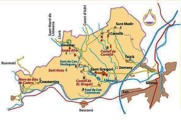
We started the route in the same town of Sant Gregori where, at the roundabout at the entrance to the town, coming from Girona along the GI-531, we will take the local road that goes towards Cartellà, to go to visit the first watch of our route.
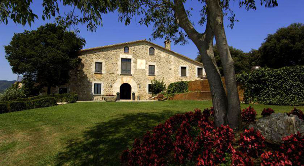
1.- CAN BIEL: About 2 km. After leaving Sant Gregori, on the left in Cartellà direction, we will find a farmhouse that, although it seems abandoned, is waiting to be restored.
On the facade we can see a simple vertical clock, oriented to the south, with hour lines and decorated with a pinnacle at the top. The coordinates of the place are: Latitude, 42º00'59 '' N, Longitude, 2º45'54 '' E. It is a bit unpainted but, according to the owner, when restoring the house they will also do it with the clock.
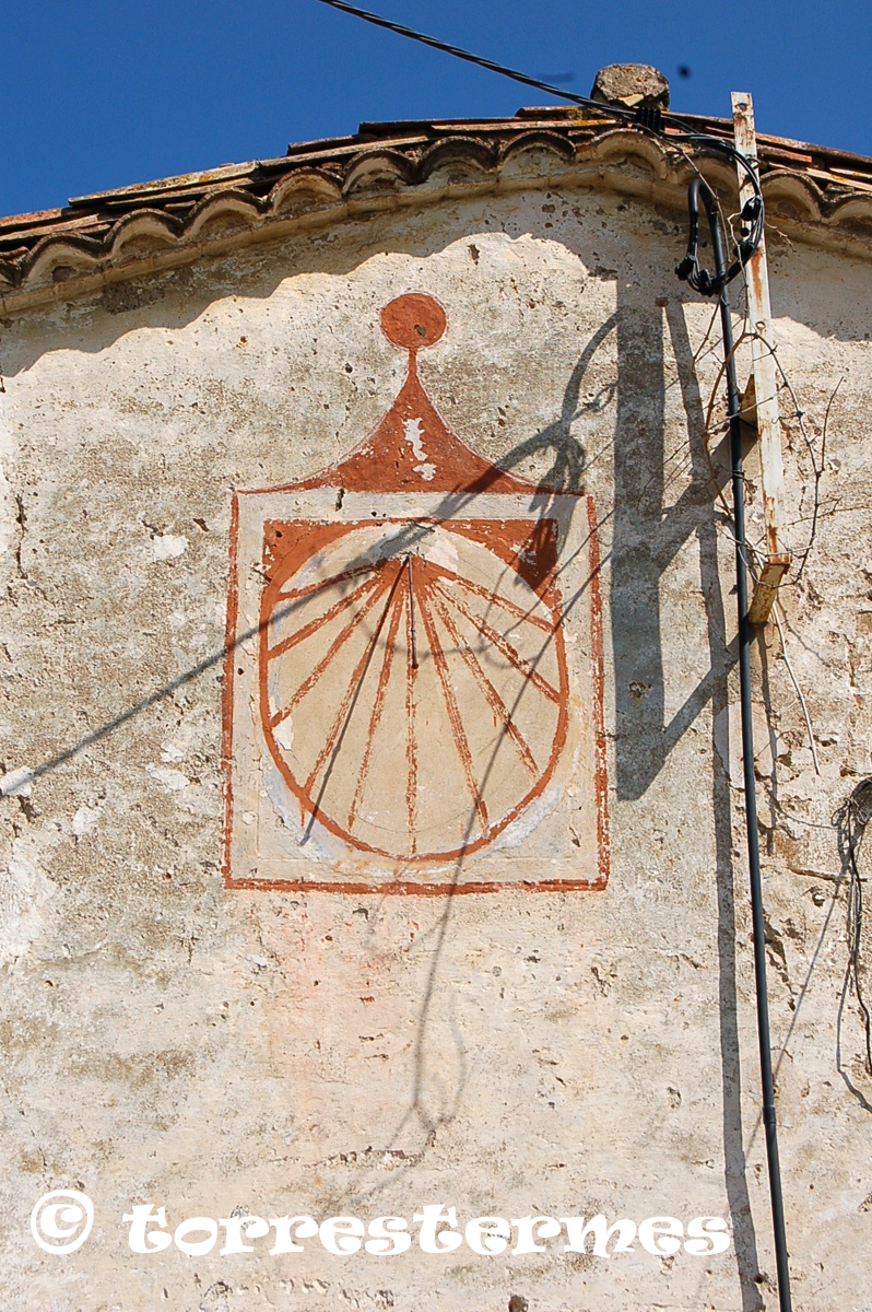
2.- CAN XIFRA VELL: Next, we will continue towards the nucleus of Cartellà, where, before reaching the junction with the GI-5312 road, on the left, we can visit the second of the route's clocks.
It is a vertical declining clock, oriented to the southeast, quite decorated and well preserved. The farmhouse where it was located was the old restaurant Can Xifra. We locate it at the following coordinates: Latitude, 42º01'21 '' N, Longitude, 2º45'57 '' E.
In the same nucleus, there is the church of Sant Feliu, where we can see the remains of an old vertical clock.
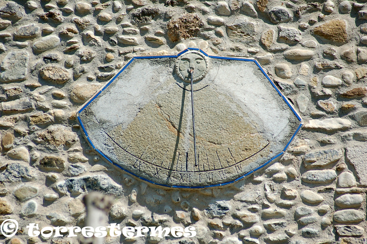
3.- CAN REIXAC: Following the route, we will take the GI-5312 road, towards the west, to, after approximately one kilometer, reach the nucleus of La Vileta, where we can visit two clocks.
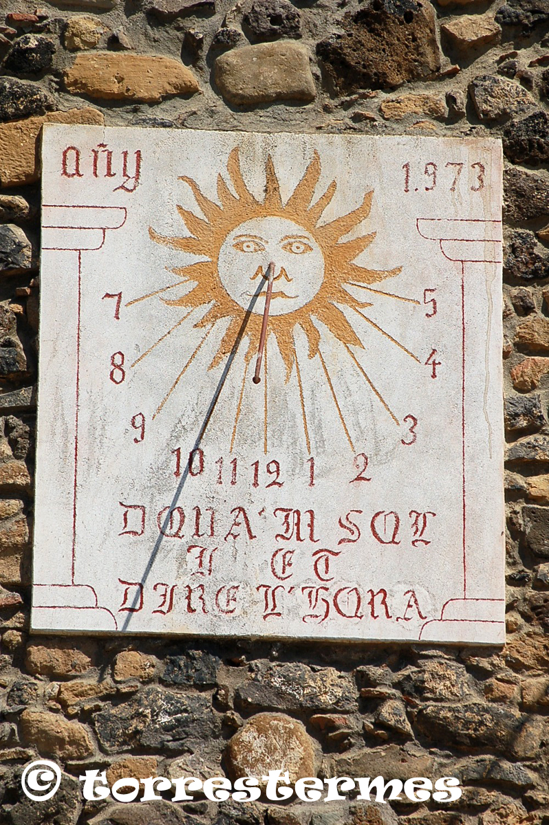
The first one is in the Can Reixac farmhouse, located to the right of our route. Here is a declining vertical clock, oriented to the southeast, built in 1973 and with a slogan that says "Donate the sun i will give l'hour", in Gothic letters. The coordinates are: Latitude. 42º01'15, Length, 2º45'28 '' E.
It is painted on a plasterboard and its conservation is good.
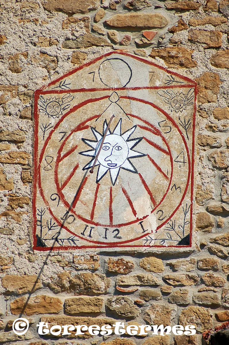
4.- CAN VILA DE LA VILETA: In the same nucleus, entering about 100 meters along a path that leaves the curve that the road makes just past Can Reixac, we will find a house that, on the façade, has a vertical clock oriented southeast.
It is not in very good condition but you can see perfectly the decoration with Arabic numerals and time lines. The coordinates to place it are: Latitude, 42º01'13 '' N, Longitude, 02º45'29 '' E.
5.- CAL PAGÈS: We will continue along the GI-5312 road, going south west, to connect, first, with the GI-5313 and, later, with the GI-531, which we will take towards Sant Gregori. After about 300 meters, on the right, we will turn off towards the center of Ginestar on the Santa Afra road.
At about 200 meters, we will find, on the right, Cal Pagès.
On the facade we can see a simple vertical clock declining, irregularly shaped, with a sun in the center, oriented to the southwest, with Roman numerals and time lines.
We will locate it in the coordinates: Latitude, 42º00'11 '' N, Longitude, 2º44'00 '' E.
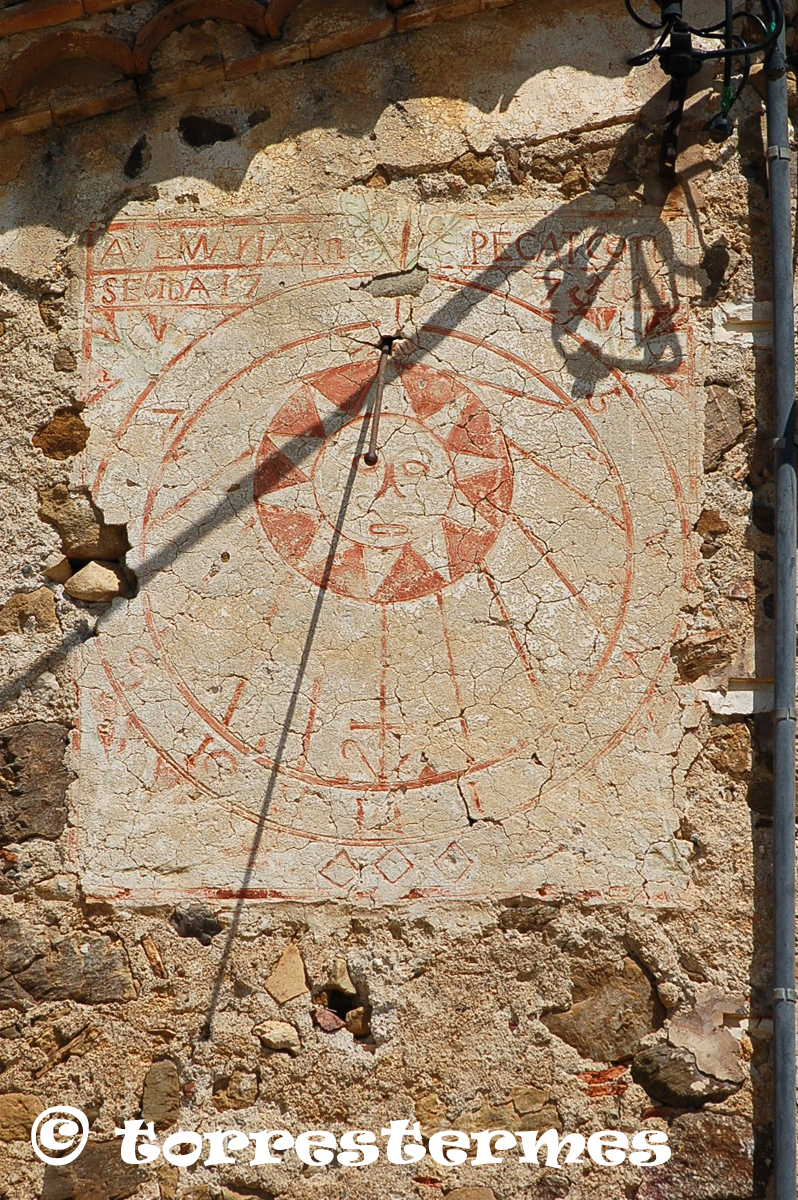
6.- CAN PINYON: Continuing along the same road that took us to Cal Pagès, about 500 meters away, on a road to the right, we will find the farmhouse of Can Pinyon.
On the façade we will see a declining vertical clock, oriented to the south, which should be restored as it is a bit deteriorated.
Anyway, it looks perfectly that it has enough decoration, numbering with Arabic characters and an inscription that says: "AVE MARIA SENSE PECAT CONSEGIDA". The coordinates to locate it are: Latitude, 42º00'25 '' N, Longitude, 2º43'50 '' E.
In order to see it, it is necessary to ask the owners for permission since it does not look good from outside the fence.
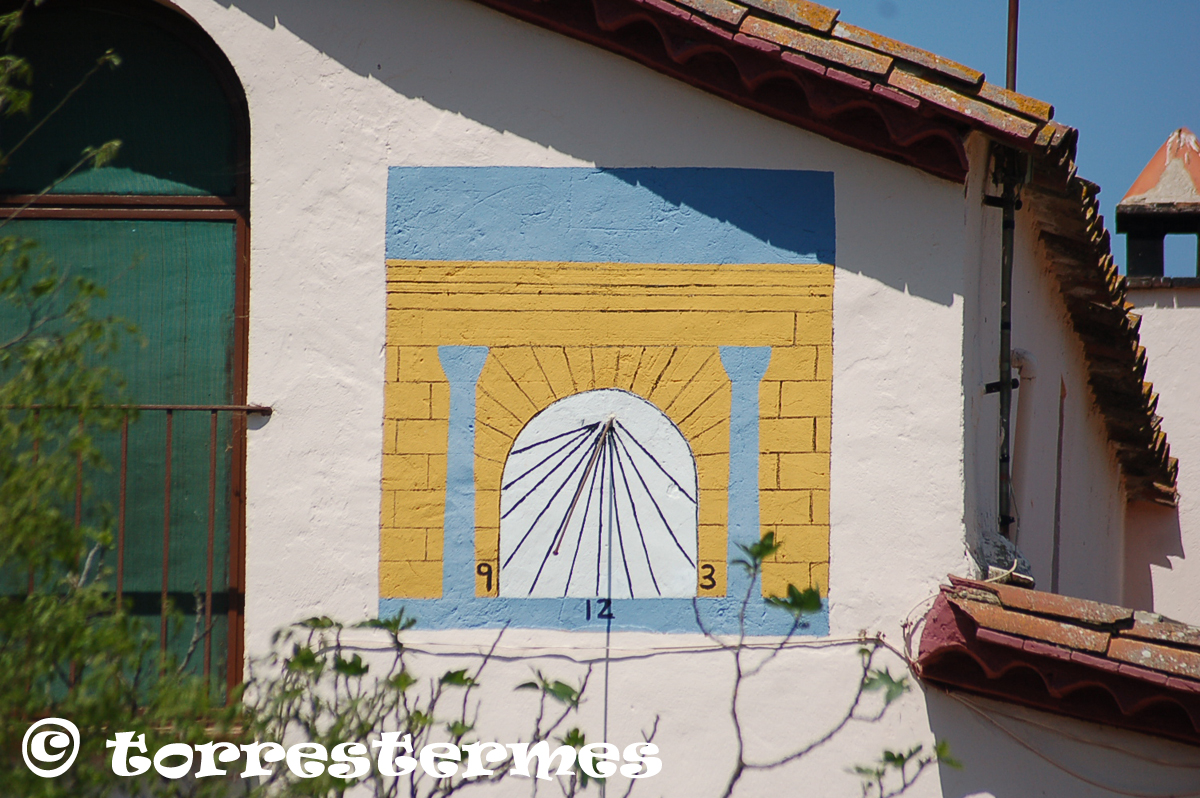
7.- CAN DARANÈS: We will go back along the road we came to, until we reach the crossroads where, on the right, we can see a restaurant (El Racó d'en Pep). We will take this paved road and, after the restaurant, about 200 meters, on the right, we will locate Can Daranés.
Painted on the facade we can see a vertical clock declining, oriented to the southeast, very simple but effective lines, with very striking colors and numbers 9, 12 and 3.
We will locate it in the coordinates: Latitude, 41º59'50 '' N, Longitude, 2º44'12 '' E.
8.- SANT GREGORI: Following the road in the same direction, we will arrive, at about 500 meters, at the junction with the GI-532 road that we will take towards Sant Gregori.
After crossing the entire village and before arriving at the roundabout where we have started the route, we will find, on the left, the square formed by the junction of the Avinguda de Girona, with the Avinguda Serra i Caballé, a horizontal meridian.
It is curious to see because the meridians are not frequent in our culture. This is a modern meridian, from the year 2006, which, in turn, is the monument that Sant Gregori dedicates to blood donors.
The author is the sculptor from Girona (Banyoles) Barraca and its peculiarity is that the line that marks the midday is a strip of grass. Coordinates: Latitude, 41º59'26 '' N, Longitude, 2º45'45 '' E.
At this point, we conclude the tour, remembering that, for those who have more time to devote to the route, in the different nuclei of the municipality of Sant Gregori, you can see a few more clocks, as many as those visited. .
Route map
|